Encountering the Past in the Sand: When the Beach Opens
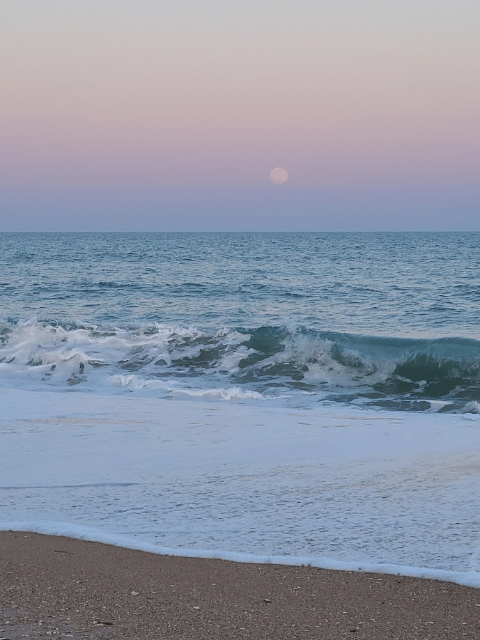
There are mornings when the beach feels newly made.
The tide has pulled back just enough to smooth the sand into a long, pale sheet, the wind from the night before erased except for faint ripples that catch the light at an angle. Ghost crab tracks cross and recross the surface, stitching together small territories that vanish with the next wave. The wrack line sits just above the reach of the water—shells, grasses, fragments of offshore life placed carefully along a boundary that shifts a little each day.
And then, walking that line, something interrupts the pattern.
At first it looks like driftwood. Dark. Angular. Out of place, but not unusual. But the closer you get, the more it resists that explanation. The pieces are too regular, too aligned. The sand around it feels different underfoot—firmer, compacted, as though something beneath it has been holding shape long before this tide receded.
What emerges is not debris, but structure.
Ribs of timber curve in a way that only makes sense once you recognize them as part of a hull. Iron fastenings stain deep into the grain. The geometry of a vessel that once moved across this water now rests within it.
The beach has not received this. It has revealed it.

Along the Onslow County coast, shipwrecks do not arrive as singular events. They exist in cycles of concealment and return. Storms strip sand away. Longshore currents redistribute what was settled. A wreck that has been buried for decades can appear in a single tide cycle, as if placed there overnight, only to be covered again before the week ends.
The shoreline is not a surface. It is a moving archive (Riggs & Ames, 2003).
A Coast That Does Not Hold Still
Standing at the edge of the water, the coastline can appear steady, almost fixed, as though the boundary between land and ocean has settled into a reliable position. The horizon holds its line. Waves repeat their approach in familiar intervals. Even the inlets, from a distance, seem to occupy defined openings in the land.
But that stability is a surface impression.
Beneath it, the coastline is in constant adjustment. Sand moves even when the water appears calm, carried alongshore by currents that shift direction with changing wind and wave conditions. Bars form offshore, migrate, and dissolve. Channels deepen and fill. The openings at places like New River Inlet or Topsail are not permanent features so much as temporary alignments of water and sediment, reshaped seasonally and sometimes abruptly after storms.
For someone approaching from offshore, especially before modern navigation, this would not have presented as a clear pathway but as uncertainty. Depth changes could occur over short distances. A channel that allowed passage one season might be obstructed the next. What looked like open water could rise into a shoal just beneath the surface, invisible until it was encountered.
Ships moving along this coast were not simply traveling past it. They were moving across a landscape that was itself in motion.
When a vessel grounded here, it was often not because of a single error, but because the environment it relied on for passage had already changed. The ship met a bottom that no longer matched expectation, and once contact was made, wave energy did the rest—breaking the structure apart and distributing its remains across the same shifting system that had caused the grounding.
Over time, those remains became part of that movement. Buried, exposed, and buried again as sand continued to migrate, they settled into the coastline not as isolated events but as elements within an ongoing process.
What appears now as a sudden discovery—a line of timbers revealed after a storm—is not the arrival of something new, but a brief moment when the motion of the coast allows what has long been present to be seen again.
Vessels Carried Into This Coast
Walk this shoreline long enough and shipwrecks begin to feel less like isolated events and more like recurring encounters with the same conditions. Different vessels, different centuries, but the same meeting between movement and a coast that does not stay where it was. What changes is not only the vessel, but the way it is lost.
Two Ways a Ship Becomes Part of the Sea
Not all shipwrecks begin the same way. Some are lost far offshore, where depth replaces sand as the defining feature. A vessel may be damaged by storm, fire, or attack, take on water, and settle downward through open water until it reaches the seafloor. The descent is vertical, the structure often remaining largely intact as it comes to rest in deeper, more stable conditions. These wrecks lie beyond the horizon, where the bottom changes more slowly and the surrounding water does not rearrange them in the same way (Ward et al., 1999; Hoyt et al., 2021).
Others meet the coast itself. Along barrier shorelines like Onslow County, ships often do not sink all at once. They run aground. A hull meets sand where water had been expected, forward motion stops, and the energy of waves and tide begins to work against the structure. The vessel lifts, pivots, and settles unevenly as water moves beneath and around it. Over time, it breaks apart. What remains is not a single intact form, but a field of structure distributed across the seabed and shoreline (Riggs & Ames, 2003; Pilkey, 1998).
Both are shipwrecks, but they belong to different processes. One settles into depth. The other becomes part of a coast that does not hold still.
Pirate Waters

Long before modern navigation, these waters were already understood as difficult to pass through cleanly. The channels around what is now Topsail Island were narrow, shifting, and often uncertain from offshore. What appears now as a continuous coastline is, and always has been, a series of openings that do not hold their shape for long.
Even today, that instability can be seen without leaving shore. After a strong storm or a week of changing wind, the edge of the waterline shifts, bars appear where there had been none, and shallow areas extend farther out than expected. A stretch of water that looked open a few days earlier begins to break differently, waves lifting and folding over something just beneath the surface. The bottom has moved, even if the horizon has not (Riggs & Ames, 2003; Pilkey, 1998).
For a vessel approaching from offshore, especially without precise depth measurements, that change would not be visible until it was too late. The hull would meet sand where water had been expected. Forward motion would slow abruptly, then stop, while the energy of the sea continued to act on the vessel. Waves begin to lift and drop the structure unevenly, pivoting it sideways, driving it further onto the bar. What had been a path forward becomes a fixed point under pressure (Riggs et al., 1995; Delgado, 1997).
Stories persist that pirates used this uncertainty to their advantage, positioning themselves within these shifting inlets where passing ships were forced into slower, more confined routes. Whether or not every account is precise, the setting itself made such encounters possible.Further north along this same coastline, in 1718, Blackbeard ran his flagship Queen Anne’s Revenge aground while entering what is now Beaufort Inlet. The ship struck a shallow shoal at the mouth of the inlet, where water depths even today remain modest—on the order of twenty to twenty-five feet at the wreck site. Rather than sinking intact into the deep ocean, it remained within a high-energy, shallow environment where waves and tidal currents gradually broke it apart. Its remains settled into the seabed and have since been buried and re-exposed as sediment continues to move across the inlet (Wilde-Ramsey & Carnes-McNaughton, 2016; Wilde-Ramsing & Carnes-McNaughton, 2018).
To learn more about Blackbeard’s Queen Anne’s Revenge Shipwreck, watch the Nautilus Productions video.
Colonial Trade and Storm-Driven Wrecks
By the mid-eighteenth century, heavily loaded merchant vessels were moving along this coastline as part of transatlantic trade. Their routes followed currents that offered efficiency, but those same currents carried them close to a shoreline that did not remain fixed.
In 1750, the Spanish ship El Salvador, part of a treasure fleet transporting gold and silver, encountered a hurricane that pushed it northward along the Gulf Stream. The storm did not introduce danger so much as concentrate it. Wind and current worked together, driving the vessel toward a coast already defined by shifting shoals and unstable inlets. Other ships in the same fleet were carried along the same path, driven ashore at different points along the Outer Banks, separated from one another by the same forces that moved them north (Shomette, 2008; Pilkey, 1998).
When El Salvador met the shoals, there was little margin left for recovery.
Only a small number of crew survived, carried ashore as the vessel came apart in the surf. The hull did not settle into the water as a whole. Instead, waves lifted and broke it against a bottom that would not hold it in one place. For a short time, portions of the structure remained visible—rigging, fragments of timber, the outline of something that had recently been intact. And then the shoreline resumed its movement. Sand shifted across what remained. Water moved through it. What had been a vessel became something distributed, its structure absorbed into sediment and carried within the same system that had stopped it, continuing to migrate along the coast (Riggs & Ames, 2003; Pilkey, 1998; Shomette, 2008).
The pattern holds: a vessel enters under force, meets a shifting bottom, and becomes part of it.
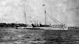
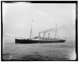
Steam and Certainty: Pulaski (1838)
By the early nineteenth century, steam navigation had begun to change expectations. Routes were more regular. Travel felt more predictable. Distance could be measured in time rather than uncertainty.
The coastline, however, had not changed.
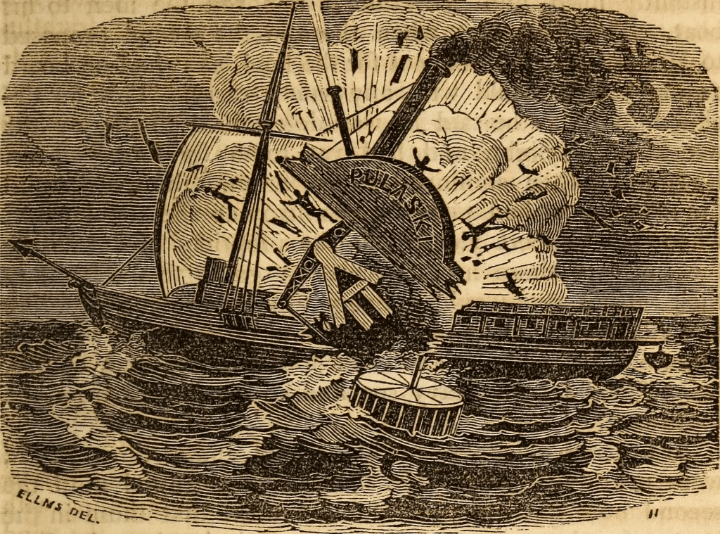
When the steamship Pulaski exploded offshore of North Carolina in 1838, the rupture was immediate. What followed did not resolve as quickly. Survivors, separated into lifeboats and fragments of wreckage, were no longer traveling across water with direction. They were moving within it (North Carolina Department of Natural and Cultural Resources [DNCR], 2016).
They drifted for more than a day, in some cases closer to two.
There was no fixed path in that movement. Coordinates were not precisely recorded, and what direction remained was shaped by current, wind, and wave rather than intention. The horizon held its line, but offered no reference. The sun marked time without marking progress. Salt settled into the skin. Thirst extended the length of the day. Movement continued, but without a way to measure where it led.
Some survivors eventually reached the barrier islands along this stretch of North Carolina, carried by those same forces rather than guided toward land. Their arrival was not coordinated or immediate, but scattered—individual landings along a shoreline that did not announce itself as destination, only as the end of exposure (DNCR, 2016). Of its 150 passengers and 37 crew, only 59 survived (Falk, 2025).
The wreck remains offshore, beyond the shifting bars where waves no longer break it apart in the same way. It does not return to the surface in the way some grounded vessels do. It settles instead into deeper water, where structure changes more slowly and remains largely out of view.
The shoreline holds something else. Not the wreck itself, but the moment when motion without direction became arrival. A place where drifting resolved, not into discovery, but into contact—where water gave way to land, and movement, at last, found its edge.
Want to learn more about the Pulaski? Listen to a podcast from Shipwrecks and Seadogs about its history.
War Along the Inlets: New River
During the Civil War, this coastline was not only a place of navigation, but of control.
New River Inlet, leading inland toward what is now Jacksonville, served as a potential access point between coastal waters and interior routes. Union naval forces patrolled the coast as part of a broader blockade, attempting to restrict movement of goods and supplies, while Confederate forces relied on smaller vessels and local knowledge of the waterways to move through the system (Browning, 2002; Stick, 1990).
For any vessel entering New River, the challenge would have been familiar.
The inlet itself was shallow and shifting, defined by sandbars that changed position with storms and tides. Navigation required timing, local knowledge, and an ability to read water that did not present itself clearly from offshore (Riggs & Ames, 2003).
Unlike some of the more widely known Civil War wreck sites along the North Carolina coast, there is no clear record of a major vessel sinking within New River itself. But the absence of a wreck does not mean the absence of difficulty. The conditions that prevent passage do not always leave a visible record. Any ship moving through that inlet would have encountered the same conditions that shape it today.
Shallow approaches, moving sand, and water that changes faster than it can be mapped. The difference is not in the coastline, only in the ships that attempt to pass through it.
Farther south along this same stretch of coast lies the Cape Fear Civil War Shipwreck District, a cluster of documented wreck sites near the approaches to the Cape Fear River and the port of Wilmington. These wrecks, concentrated off Brunswick, New Hanover, and parts of Pender County, represent vessels involved in the Confederate blockade-running trade. Ships attempting to slip past Union naval patrols carried cargo that ranged from military supplies and weapons to manufactured goods and cloth desperately needed in the South. Many were narrow, fast steamers built with shallow drafts and reinforced hulls designed to move quickly through inlets and across shoals. Their loss was not incidental, but patterned—occurring in a region where shifting channels, shallow bars, and the pressure of pursuit converged. Archaeological surveys of this coastline describe a dense concentration of wreck sites associated with these movements, forming one of the most significant Civil War maritime landscapes along the Atlantic seaboard (North Carolina Office of State Archaeology, n.d.; Browning, 2002; Hall, 2004).
Working Maritime Coast: William H. Sumner (1919)


In 1919, the schooner William H. Sumner approached this same coastline carrying cargo northward. The conditions it encountered were not new. The channel it relied on had shifted beyond what the vessel could safely cross.
The grounding was not violent, but it was final.
Accounts from the time suggest that by the final days of the voyage, conditions aboard the vessel had already begun to shift. Rations had reportedly run low, and attention moved away from navigation. In the hours after the grounding, the captain was found dead in his cabin from a gunshot wound, and the ship’s mate was later charged with mutiny and murder. Testimony conflicted. Some described tension among the crew, others described familiarity and routine. The trial that followed ended without resolution, leaving the cause of the captain’s death uncertain (North Carolina Shipwrecks, n.d.; Wrightsville Beach Magazine, 2015).
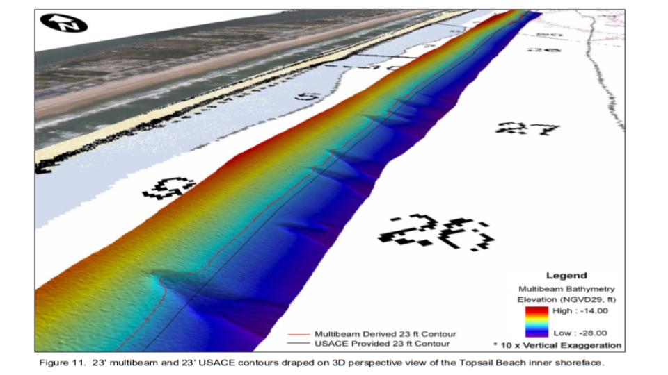
Once the hull met the sandbar near Topsail Inlet, where multiple vessels have grounded over centuries of shifting channels, wave energy began to work against it, gradually breaking the structure apart (Riggs & Ames, 2003; Pilkey, 1998; Hall, 2004). Salvage efforts removed what could be taken. What remained did not leave with it. It settled into the shoreline system, where it was taken in and buried beneath moving sand (Riggs & Ames, 2003; Pilkey, 1998).
Over time, and then at intervals shaped by storms, it appeared again.
Storms and low tides continue to strip away the sand that covers portions of the wreck, exposing curved timbers that seem, for a short time, to return. These exposures are often described as discoveries, but the structure has been present throughout, shifting between visibility and concealment as sediment moves across it (Riggs & Ames, 2003). When these timbers reappear, they are not simply objects to be collected. As registered historic shipwreck remains, they are protected under state law, and removing or disturbing them is prohibited, preserving both the structure and the record it represents (ABC45 News, 2024).
The wreck does not travel. The coastline moves around it.
Wrecks Beyond the Shoals
Farther offshore, beyond the shifting bars and inlets, the nature of shipwrecks begins to change.
In deeper water, vessels are less likely to run aground and more likely to be lost through damage that begins within the ship itself—fire, structural failure, or, in the case of the North Carolina coast during World War II, torpedo strikes from German U-boats operating just off the continental shelf (Hoyt et al., 2021; Blair, 2000).
By the time of World War II, this stretch of coastline was already part of what is often called the “Graveyard of the Atlantic,” a name shaped by centuries of shipwrecks driven by storms, shifting shoals, strong currents, and difficult navigation along the North Carolina coast (Stick, 1990; Hoyt et al., 2021). The war did not create this pattern, but added to it, concentrating losses offshore as vessels were targeted in transit. Tankers and cargo ships moving along the eastern seaboard were struck at sea, often at night, their hulls breached below the waterline as they traveled.
The process is different. Instead of grounding, there is descent.
A vessel lists, loses buoyancy, and slips beneath the surface, settling onto the seafloor often in a more intact form than those broken apart in shallow surf. Once compromised, these ships took on water rapidly and sank into deeper channels where the seabed lay far below the reach of waves (Wells & McNinch, 1991).
In some cases, even when a wreck is located, its identity remains uncertain. Historical comparisons of structure, propulsion, and location have led to tentative identifications—such as the possible association of certain offshore remains with Civil War–era blockade runners—but these connections are not always definitive and may remain unresolved despite decades of study (Stallman, 2011).
Off the coast of Onslow County, these deeper wrecks remain present, though rarely visible from shore.These wrecks are not isolated features, but part of a broader offshore field of structure, scattered across the continental shelf. Some have been mapped and studied, while others remain only partially defined, their forms intact below the reach of waves. What defines them is not their visibility, but their persistence—structures that remain in place long after the events that created them, shaping the surrounding environment in ways that are not immediately seen.
Storm Without Shore: Normannia (1924)
Vessels in deeper water faced a different kind of exposure than those nearer to the shoals.
In 1924, the Normannia foundered during a storm offshore. The forces at work were not those of shifting shoals, but of sustained wind, wave height, and structural stress. Far from the influence of the coastline’s sandbars, the vessel did not run aground. It remained in open water until the structure failed (Gentile, 1992).
As the hull lost integrity, water entered faster than it could be expelled. Stability gave way. The vessel listed, settled, and slipped beneath the surface (Gentile, 1992).
There was no bar to hold it, no shoreline to break it apart—only depth to receive it.
March 1942: A Concentrated Loss Offshore
In March of 1942, multiple vessels moving along this coastline were struck within a matter of days, part of a concentrated period of U-boat activity along the North Carolina coast.
Other vessels from this same period reflect the intensity of offshore loss during the war. The tanker Naeco, more than 400 feet in length, was struck by a torpedo from U-124 and broke apart before sinking, its bow and stern sections settling separately on the seafloor miles apart. The tanker Esso Nashville was also torpedoed that year; its bow section sank offshore while the stern remained afloat long enough to be recovered, later refitted and returned to service. When the tanker John D. Gill was struck by U-158, where 23 were lost and 26 survived, burning oil ignited on the water, creating a fire visible from shore, extending the event into the night sky itself (Taylor, 2025).


These vessels did not meet the coast through sand. They were lost to force applied below the waterline, their structures descending into deeper channels beyond the reach of waves (Hoyt et al., 2021; Blair, 2000; Wells & McNinch, 1991).
Over time, these wrecks become stable structures in deeper water, less influenced by shifting sand and more by currents, corrosion, and biological growth. They are still part of the same coastal system, but they are shaped by depth rather than motion (Paxton et al., 2023).


War Along the Shore: Observation Without Contact
While vessels were being lost offshore, the coastline itself became part of the wartime landscape.
Along Topsail Island, a series of observation towers were constructed as part of Operation Bumblebee, where military personnel tracked missile tests and coastal activity from elevated positions above the shoreline. From these towers, the ocean was not empty space but an active field—ships moving along the horizon, and at times, evidence of conflict unfolding beyond direct reach (Island Life NC, 2025).
The coastline did not receive these wrecks.
But it witnessed them.
Collision in Transit: Cassimir (1942)
Not all vessels lost during this period were the result of attack.
The Cassimir, built in 1920, sank in 1942 following a collision with the freighter Lara. The loss occurred offshore, in deeper water, where the structure did not ground but instead descended to the seafloor. Its presence reflects a different kind of vulnerability—navigation intersecting with proximity rather than conflict or storm (Gentile, 1992).
The outcome, however, remains consistent.
The vessel did not meet sand.
It entered depth.


Modern Abandoned Vessels: Those That Become Something Else
Along the coast today, abandoned vessels follow a similar trajectory, though their timeline is still unfolding. Shrimp boats grounded on shoals or left after mechanical failure may remain in place for years, shifting slightly with storms but never fully leaving.
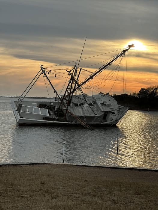
During that time, they begin to change.
Osprey use the elevated structure for nesting. Barnacles attach to submerged surfaces. Fish gather beneath the hull where shade and form offer protection. In a sandy coastal system, any stable structure creates opportunities for life to organize around it.
But what develops on these vessels depends strongly on where they come to rest.
When a boat grounds on a shoal or nearshore bar, the surrounding environment remains in constant motion. Waves pass through the structure with each tide cycle, sand migrates around the hull, and storms periodically bury or expose different portions of the wreck. Habitat in these places is shaped by disturbance. The organisms that establish themselves must tolerate shifting sediment, abrasion, and periodic exposure to air.
The first arrivals appear quickly. Within weeks, thin microbial films and algae coat the surfaces of exposed wood, steel, or fiberglass. Barnacles and oysters follow, attaching themselves wherever water continues to move across the hull. Mussels cluster along beams and ribs where currents deliver suspended food. Small fish begin to gather in the shadows beneath the structure—pinfish, blennies, and juvenile black sea bass slipping into crevices created by broken ribs or propeller shafts. Sheepshead move in to feed on barnacles and shellfish, while blue crabs and shrimp occupy pockets where sand collects between fragments.
Over time, the wreck becomes less a single object than a patch of structure embedded in the moving beach system. Sandbars migrate across it. Portions disappear beneath sediment, only to reappear after storms. Habitat here is temporary and episodic, shaped by the same forces that buried the vessel in the first place.
View interactive Map of Derelict Vessels in North Carolina.
Farther offshore, the process unfolds differently.
When a vessel sinks into deeper water beyond the reach of breaking waves, the surrounding seabed is more stable and the structure often settles largely intact. Steel hulls, decks, and internal compartments create vertical relief in a landscape otherwise dominated by sand. Hard surfaces are scarce along this portion of the continental shelf, and life responds quickly when they appear.
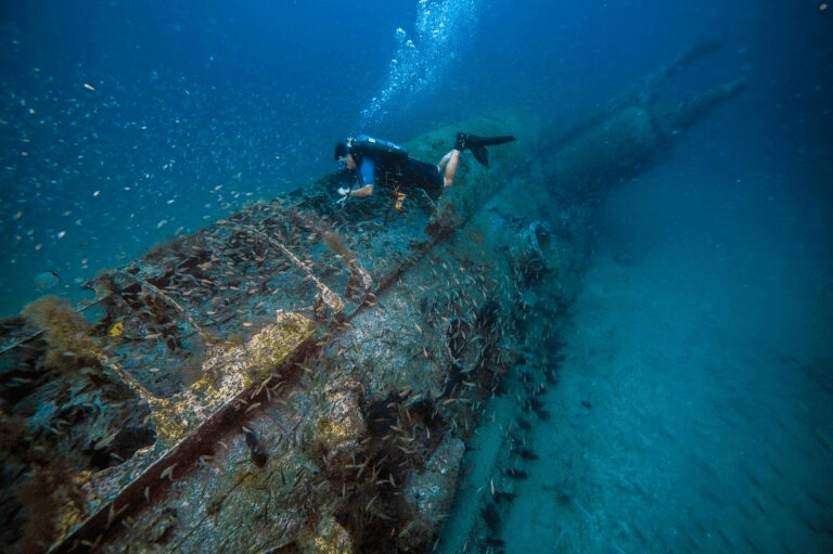
Within weeks, bacterial films coat the structure. Barnacles, hydroids, and tube worms attach soon after, followed by sponges, anemones, and soft corals that require firm substrate to establish. Over months and years, these organisms layer over one another, transforming the wreck from bare metal or timber into something resembling natural reef.
Within weeks, bacterial films coat the structure. Barnacles, hydroids, and tube worms attach soon after, followed by sponges, anemones, and soft corals that require firm substrate to establish. Over months and years, these organisms layer over one another, transforming the wreck from bare metal or timber into something resembling natural reef.
Fish respond just as quickly. Small schooling species—tomtate, baitfish, and spadefish—begin to circle the structure, drawn to shelter and feeding opportunities. As prey accumulates, larger predators follow. Snapper and grouper hold close to the hull, amberjack patrol the upper water column, and barracuda and sharks move through the surrounding water where prey becomes concentrated (Bohnsack & Sutherland, 1985; Paxton et al., 2023).
In waters off North Carolina, these offshore wrecks are also known for attracting one of the coast’s most recognizable predators. Sand tiger sharks often patrol the edges of wreck sites along the continental shelf, moving slowly through the water column where schools of fish gather around the structure (Castro, 2011; Paxton et al., 2023). Unlike fast-moving pelagic sharks, sand tigers tend to hover deliberately near reefs and wrecks, conserving energy while watching the dense concentrations of prey that form there (Castro, 2011). Divers frequently encounter them circling shipwrecks in loose groups, their presence marking the final stage of a habitat that began as bare metal or timber settling onto an otherwise sandy seafloor (Paxton et al., 2023).
Over decades, these deeper wrecks can support complex communities that persist long after the vessel itself begins to corrode. The structure weakens slowly, but before it collapses it may host a dense network of organisms comparable to natural hard-bottom reefs.

Artificial Reefs and Intentional Sinking
Recognizing this ecological potential, many coastal states—including North Carolina—have intentionally sunk vessels as part of artificial reef programs. Before sinking, ships are stripped of fuels, wiring, plastics, and other materials that could pollute surrounding waters. What remains is the structural framework: steel decks, beams, and bulkheads that provide vertical complexity.
Once placed on the seafloor, these vessels follow much the same ecological trajectory as accidental wrecks, often more quickly because the structure is intact and positioned on a stable bottom. Fish communities can begin forming within months, with predators arriving as prey species establish themselves (Bohnsack & Sutherland, 1985; Pickering & Whitmarsh, 1997).
The resulting reef does more than host new organisms. It changes the surrounding environment. Currents interacting with the hull create eddies that trap plankton and organic material. Sand that once held little structure becomes a landmark on the seafloor where life gathers.
But the distinction between prepared artificial reefs and abandoned vessels remains important. Ships intentionally sunk for reef programs are cleaned to reduce contamination, while vessels left to deteriorate in place undergo corrosion and material breakdown that can introduce contaminants into surrounding waters as their structure degrades (MacLeod, 2006).
Even so, the ecological impulse is the same. Wherever the coast receives structure, life organizes around it.
In some cases, this ecological response has led coastal managers to intentionally place vessels on the seafloor as artificial reefs, recognizing that stable structure can support complex marine communities. Along this coastline, however, similar structures are not treated in the same way. Some wrecks are preserved as part of the historical record, protected because they represent events that cannot be reconstructed once disturbed. Others are managed as hazards, their removal shaped by environmental risk and navigational safety. Still others are placed deliberately, prepared and sunk to provide habitat without the long-term effects of deterioration. What appears similar from the surface carries different meanings depending on how it is understood—as a record, a risk, or a design.
Along the Topsail Island coast, vessels have been intentionally placed on the seafloor as part of North Carolina’s artificial reef program, where cleaned ships are sunk to create habitat for fish and other marine life while providing new structure in otherwise sandy environments (Report, 2024).
What the Coast Does With What We Leave Behind
Shipwrecks are often described as endings, but along the Onslow coast they function more as transitions.
A vessel moves through stages. It carries people and cargo, meets a coastline that does not hold still, and becomes structure. That structure gathers life, shifts within the movement of sand, and settles into memory. The boundaries between these stages are not fixed. They move with the same currents and tides that shape the shoreline itself.
Nothing here is entirely lost. It is redistributed.
Wood, iron, fiberglass, and story all enter the same system, resurfacing when conditions allow. What appears after a storm is not new, but newly visible—a brief alignment of movement and exposure that allows what has long been present to be seen again.
The beach does not keep everything in sight. But it keeps everything, waiting for the moment the sand moves and the past becomes visible again.
References
Blair, C. (2000). Hitler’s U-boat war: The hunted, 1942-1945. Modern Library.
Bohnsack, J. A., & Sutherland, D. L. (1985). Artificial Reef Research: A Review with Recommendations for Future Priorities. Bulletin of Marine Science, 37(1), 11-39(29). https://www.ingentaconnect.com/content/umrsmas/bullmar/1985/00000037/00000001/art00003
Browning, R. M. (2002). Success is all that was expected: The south Atlantic blockading squadron during the Civil War. Potomac Books.
Castro, J. I. (2011). The sharks of North America. Oxford University Press.
Delgado, J. P. (1997). Encyclopaedia of underwater and maritime archaeology. British Museum Press.
Falk, C. (2025, November 26). The wreck of the S.B. Pulaski (1838). Sedwick Coins Blog. https://sedwickcoins.blog/2025/11/10/the-wreck-of-the-s-b-pulaski-1838/
Gentile, G. (1992). Shipwrecks of North Carolina from Hatteras inlet south. Gary Gentile Productions.
Hall, W. (2004). Archaeological Remote Sensing Survey of Topsail and West Onslow Beaches Offshore Borrow Areas (DACW54-03-D-0002-003). U.S. Army Corps of Engineers, Wilmington District. https://www.saw.usace.army.mil/Portals/59/docs/coastal_storm_damage_reduction/TBGRR/Appx_U_Cultural%20Resources%20Report.pdf
Hoyt, J. C., Bright, J. C., Hoffman, W., Carrier, B., Marx, D., Richards, N., Sassorossi, W., Davis,
K., Wagner, J., & McCord, J. (2021). Battle of the Atlantic: A Catalog of Shipwrecks off North Carolina’s Coast from the Second World War (BOEM IA M10PG00048). BOEM’s Office of Renewable Energy Programs and NOAA’s Office of National Marine Sanctuaries. https://www.govinfo.gov/app/details/GOVPUB-I–b4c8d5485d6e8270384848d0e6d5efbc
Island Life NC. (2025, September 3). Operation bumblebee— the story of the topsail towers. https://islandlifenc.com/operation-bumblebee-topsail-towers/
Macleod, I. D. (2006). Corrosion and conservation management of iron shipwrecks in Chuuk
lagoon, Federated States of Micronesia. Conservation and Management of Archaeological Sites, 7(4), 203-223. https://doi.org/10.1179/135050306793137359
NC DNCR. (2016, June 14). The Pulaski explosion, 1838. North Carolina Department of Natural and Cultural Resources. https://www.dncr.nc.gov/blog/2016/06/14/pulaski-explosion-1838
NC OSA. (n.d.). Shipwrecks of North Carolina. North Carolina Office of State Archaeology. https://archaeology.ncdcr.gov/programs/uab/education/shipwrecks
Paxton, A. B., McGonigle, C., Damour, M., Holly, G., Caporaso, A., Campbell, P. B.,
Meyer-Kaiser, K. S., Hamdan, L. J., Mires, C. H., & Taylor, J. C. (2023). Shipwreck ecology: Understanding the function and processes from microbes to megafauna. BioScience, 74(1), 12-24. https://doi.org/10.1093/biosci/biad084
Pickering, H., & Whitmarsh, D. (1997). Artificial reefs and fisheries exploitation: A review of the ‘attraction versus production’ debate, the influence of design and its significance for policy. Fisheries Research, 31(1-2), 39-59. https://doi.org/10.1016/s0165-7836(97)00019-2
Pilkey, O. H. (1998). The North Carolina shore and its barrier islands: Restless ribbons of sand. Duke University Press.
Report, S. (2024, March 23). Artificial reef program sinks vessel off topsail. Coastal Review. https://coastalreview.org/2020/07/artificial-reef-program-sinks-vessel-off-topsail/
Riggs, S. R., & Ames, D. V. (2003). Drowning the North Carolina coast: Sea-level rise and estuarine dynamics (0-9747801-0-3). North Carolina Sea Grant. https://repository.library.noaa.gov/view/noaa/38437
Riggs, S. R., Cleary, W. J., & Snyder, S. W. (1995). Influence of inherited geologic framework on barrier shoreface morphology and dynamics. Marine Geology, 126(1-4), 213-234. https://doi.org/10.1016/0025-3227(95)00079-e
Shomette, D. G. (2008). The price of amity: Of wrecking, piracy, and the tragic loss of the 1750 Spanish treasure fleet. The Northern Mariner / Le marin du nord, 18(3-4), 25-48. https://doi.org/10.25071/2561-5467.354
Stallman, D. A. (2011). Echoes of topsail: Stories of the island’s past (3rd ed.). Carlisle Printing.
Stick, D. (1990). The Outer Banks of North Carolina, 1584-1958. The University of North Carolina Press.
Taylor, A. (2025). John D. Gill. Sunken Ships OBX. https://sunkenshipsobx.com/john-d-gill/
Ward, I., Larcombe, P., & Veth, P. (1999). A new process-based model for wreck site formation. Journal of Archaeological Science, 26(5), 561-570. https://doi.org/10.1006/jasc.1998.0331
Wells, J. T., & McNinch, J. E. (1991). Role Of Inlet Dynamics In Scour And Burial Of Marine Artifacts In Energetic Coastal Settings. In Maritime heritage (65th ed., pp. 87-96). WIT Press. https://doi.org/10.2495/MH030081
Wilde-Ramsey, M. U., & Carnes-McNaughton, L. F. (2016). Blackbeard’s Queen Anne’s Revenge and Its French Connection. In Pieces of Eight: More Archaeology of Piracy (pp. 15-56). University Press of Florida.
Wilde-Ramsing, M. U., & Carnes-McNaughton, L. F. (2018). Blackbeard’s sunken prize: The 300-Year voyage of Queen Anne’s revenge. UNC Press Books.